
For this network analysis, we are hoping to determine the best possible location for additional Licensing and Inspections offices in Philadelphia. There are currently seven offices for the entire city. The public libraries are the potential sites for a new mobile L&I offices to be established. There are fifty-seven libraries in the city, but only four of them will be selected as mobile L&I locations. We are trying to minimize the distance traveled to the L&I offices for the most amount of people. That means our analysis will be weighted by population. What this literally means is that the distance traveled from the centroid of the census tract is multiplied by the population, and the product of distance times population is compared to find the locations that have the lowest travel distance for the most people. Finally, we will compare the census tract data for the tracts closest the original seven L&I offices with the census tract data for the new total of eleven offices.
These analyses require tools that use a method called Dykstra’s algorithm. In this algorithm, a shortest path between two nodes is determined. Then, for each node adjacent to the end of that path, the next shortest path is selected, and then the nodes closest to that new end node are open for evaluation. This is repeated until the wished for node is found as part of the shortest path selection.
Methods:
We started with the same network dataset of the Philadelphia street network that we used for the last analysis. We also had the Philadelphia tracts, along with the information joined to them from earlier labs focused on solar development in the city. Finally, we could work with the L&I office locations, and the Philadelphia library locations. In order to start the analysis, we first needed to find the centroid, or geographic center, of each tract. The centroid is what we are basing the analysis of distance upon, as a representative average of the distance that the population in that tract would need to travel.
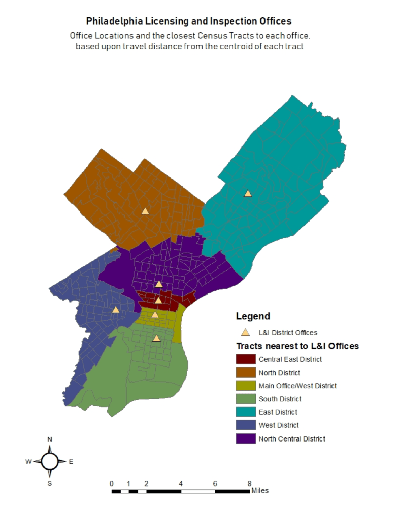
Once we have found the centroids, we can first determine the closest location to each of the original L&I offices. Using the Closest Facility tool, we can use the L&I offices as the Facility points, and the centroids as the Incident points. By measuring exclusively with distance, we determine which census tracts are closest to each original L&I office.
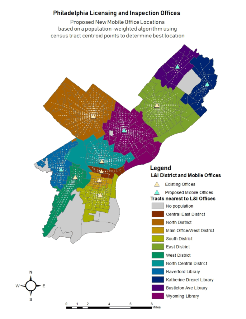
Next, we want to determine which of the fifty-seven library locations would be ideal for our four new mobile L&I offices. For this analysis, we are using the Location-Allocation tool in ArcGIS. This tool will allow us to input both the existing L&I locations, marking those as required in our output, and the library locations as candidates based on the population-weighted distance. By telling the Location-Allocation tool that we want eleven total in the final output, it will automatically select the seven existing since we entered them as required, and then choose the four library locations that minimize the distance to travel for the most people. The comparison of the data between the two sets of locations is below:
| Facility Name | Facility Number | Population | Average Distance to Office in meters | Population Density per km | Percent Solar |
| Central East District | 1 | 43130 | 1549.719 | 0.000167 | 0.1741% |
| North District | 2 | 302980 | 4023.231 | 0.000246 | 0.2084% |
| Main Office/West District | 3 | 60790 | 1548.916 | 0.00013 | 0.1725% |
| South District | 4 | 168513 | 2500.085 | 0.000346 | 0.0731% |
| East District | 5 | 459452 | 5133.038 | 0.000274 | 0.4239% |
| West District | 6 | 286226 | 3533.349 | 0.000151 | 0.1649% |
| North Central District | 7 | 248566 | 3397.431 | 0.000211 | 0.0664% |
| Facility Name | Facility Number | Population | Average Distance to Office | Population Density per km | Percent Solar |
| Central East District | 1 | 35148 | 1568.646 | 0.000164 | 0.1925% |
| North District | 2 | 215948 | 4061.516 | 0.000289 | 0.2414% |
| Main Office/West District | 3 | 62168 | 1417.476 | 0.000097 | 0.1907% |
| South District | 4 | 172422 | 1864.035 | 0.000119 | 0.0653% |
| East District | 5 | 233100 | 3260.269 | 0.000227 | 0.4257% |
| West District | 6 | 139013 | 3054.662 | 0.000162 | 0.2471% |
| North Central District | 7 | 159112 | 2584.02 | 0.000211 | 0.0806% |
| Haverford Library | 8 | 147213 | 2210.298 | 0.000126 | 0.0859% |
| Katherine Drexel Library | 28 | 62434 | 2975.2 | 0.000382 | 0.3037% |
| Bustleton Ave Library | 33 | 63628 | 2294.48 | 0.000345 | 0.7806% |
| Wyoming Library | 56 | 279471 | 3339.33 | 0.000181 | 0.0605% |
Results:
As you can see between the two maps above, the only district that remains essentially the same is the North District. The central north area is reallocated to Wyoming Library, which does reduce the population served by the North District Office, but does not meaningfully reduce the average distance needed to travel. The East District Office service area, which definitely had the longest average distance traveled, is supplemented by two additional locations in the far Northeast. The West District Office is supplemented by one additional location in the further north areas of West Philadelphia at Haverford Library.
According to the tables of data for each office location, again, the North, Central East, and Main District are the only ones whose average distance is relatively unchanged. For Central East and Main, it is likely because they are so close together that the travel distances are already very low and don’t need any supplementing. For the North District, it has relatively high population and population density, but essentially was outweighed by the extreme distances of the East District, which pulled two of the four new locations in for coverage.
Conclusion:
It is interesting that despite being so far from their nearest office, and even further from the Main Office, the tracts of the East District Office have the highest percent of solar development. Even after the reallocation of tracts to new offices, the three in the Northeast all have very high percent solar development compared to the rest of the city. In comparison, the North District and West District do have higher solar development, and the new office at Wyoming Library appears to serve a low solar development area. However, the South District is also fairly low in development, and the West District appears to have met its average distance requirement with some tracts that are more dense and very close, and some less dense and very distant tracts in the far Southwest.
The Wyoming Library and North Central District seem to especially need resources for solar development. However, since this analysis is weighted simply based upon population and distance, it doesn’t capture where the resources might be most needed. It would be interesting to run this analysis weighted by solar development and see where the offices might be located. In addition, simply being close to an office doesn’t appear to help in solar development. This is possible because so much of the process for permitting runs out of the Main Office, during short business hours. This would make it hard for anyone who needs to work every day, can’t take time off, or doesn’t have childcare to make multiple trips to the main office.
It seems like having programs available at the local libraries where much of the permitting process could be walked through and submitted during alternate hours, accessible to those who have to work during the day, would be a great way to assist. Even more importantly though would be the financial and infrastructural support that would allow more Philadelphia residents to improve and make their homes sustainable.

You must be logged in to post a comment.